
Related Images


Download:
| Tiny | 213x128 | View | Download |
| Small | 426x256 | View | Download |
| Medium | 852x512 | View | Download |
| Large | 1704x1024 | View | Download |
| Original svg | 1831x1100 | View | Download |
| Original as jpg | 1831x1100 | View | Download |
This image was acquired from
wikimedia. It was marked as Public Domain or CC0 and is free to use. To verify, go to the source and check the information there.
Looking for more info about this image?
Try a Google Reverse Image Search for it.
Try a Google Reverse Image Search for it.
Keywords from Image Description:
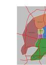
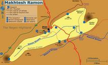
Maktesh Ramon Map en.svg en Map of Makhtesh Ramon indicating main routes and attractions to be used to Hebrew parallel can be found at File Maktesh Ramon Map svg The numbered locations are The Carpentry Saharonim campground Saharonim Fort and spring The Ammonite wall Road leading to field school alpaca farm observatory Lotz