
Related Images


Download:
| Tiny | 128x128 | View | Download |
| Small | 256x256 | View | Download |
| Medium | 512x512 | View | Download |
| Original | 768x768 | View | Download |
This image was acquired from
wikimedia. It was marked as Public Domain or CC0 and is free to use. To verify, go to the source and check the information there.
Looking for more info about this image?
Try a Google Reverse Image Search for it.
Try a Google Reverse Image Search for it.
Keywords from Image Description:
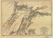
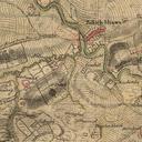
Mansewood. en Mansewood as depicted in William Roy's Military Survey of Scotland The Drumlin on which Mansewood is located is shown as the oval shaded area in the lower left It is bounded by Henry's Croft farm in the South West the original Eastwood Kirk now Eastwood Old Cemetery to the West Auldhouse to the North and Hillhead House