
Related Images


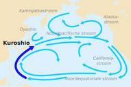


Download:
| Tiny | 204x128 | View | Download |
| Small | 408x256 | View | Download |
| Original svg | 689x432 | View | Download |
| Original as jpg | 689x432 | View | Download |
This image was acquired from
wikimedia. It was marked as Public Domain or CC0 and is free to use. To verify, go to the source and check the information there.
Looking for more info about this image?
Try a Google Reverse Image Search for it.
Try a Google Reverse Image Search for it.
Keywords from Image Description:
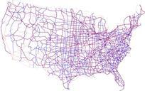
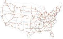
Map of current Interstates.svg Map of the present Interstate Highway System in the United States Labels Twodigit interstates px solid BED dark orange line Selected threedigit interstates px solid FF blue line Selected planned interstates px dashed AC green dashed line nationalatlas gov pdf National Atlas SPUI spuimap Road maps