
Related Images


Download:
| Tiny | 479x128 | View | Download |
| Original png | 569x152 | View | Download |
| Original as jpg | 569x152 | View | Download |
This image was acquired from
wikimedia. It was marked as Public Domain or CC0 and is free to use. To verify, go to the source and check the information there.
Looking for more info about this image?
Try a Google Reverse Image Search for it.
Try a Google Reverse Image Search for it.
Keywords from Image Description:
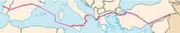
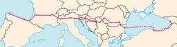
Map overview. Map of the European Route Handdrawn based on Image European UnionCIA WFB Map from CIA World Factbook public domain dots were plotted freehand on approximate coordinates Dots are east to west La Corua Bilbao San Sebastian Bordeaux Sainttienne Lyon Turin Verona Venice Trieste Ljubljana Zagreb Belgrade Timisoara Craiova