
Related Images
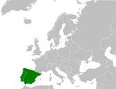
This image was acquired from
wikimedia. It was marked as Public Domain or CC0 and is free to use. To verify, go to the source and check the information there.
Looking for more info about this image?
Try a Google Reverse Image Search for it.
Try a Google Reverse Image Search for it.
Keywords from Image Description:
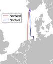
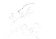
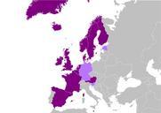
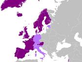
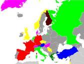
Map europe NORD.LINK and NorGer cable.svg Leitungsverlauf der geplanten NORD LINK rot punktiert und der geplante Leitungsverlauf mehrere Varianten der NorGer blau punktiert Own based on File Blankmapeurope svg and File Blank map europe Nordned cable svg Projected route for NORD LINK taken from prognos html Wdwd for map see File