
Related Images


Download:
| Tiny | 184x128 | View | Download |
| Small | 369x256 | View | Download |
| Medium | 739x512 | View | Download |
| Original svg | 1300x900 | View | Download |
| Original as jpg | 1300x900 | View | Download |
This image was acquired from
wikimedia. It was marked as Public Domain or CC0 and is free to use. To verify, go to the source and check the information there.
Looking for more info about this image?
Try a Google Reverse Image Search for it.
Try a Google Reverse Image Search for it.
Keywords from Image Description:
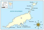
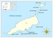
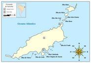
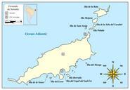
Map of Fernando de Noronhaen.svg en Map of Fernando de Noronha Selfmade in Inkscape coastline based on Landsat photo ancorage points and island names based on ladatco HTM Mysid Map of Fernando de Noronhapt svg Other versions of Fernando de Noronha translation possible Maps of Fernando de Noronha