
Related Images


Download:
| Tiny | 90x128 | View | Download |
| Small | 180x256 | View | Download |
| Medium | 361x512 | View | Download |
| Large | 722x1024 | View | Download |
| Original | 1083x1536 | View | Download |
This image was acquired from
wikimedia. It was marked as Public Domain or CC0 and is free to use. To verify, go to the source and check the information there.
Looking for more info about this image?
Try a Google Reverse Image Search for it.
Try a Google Reverse Image Search for it.
Keywords from Image Description:
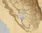
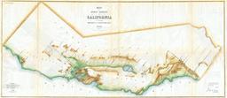
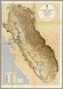
Map of the San Joaquin Sacramento and Tulare Valleys . Map of San Joaquin Sacramento and Tulare Valleys State of California prepared under the direction of the Board of Commissioners on Irrigation appointed under the Act of Congress approved March rd showing the country that may be irrigated and provisional system of irrigation