Download:
| Tiny | 133x128 | View | Download |
| Small | 267x256 | View | Download |
| Medium | 534x512 | View | Download |
| Original | 1007x964 | View | Download |
This image was acquired from
wikimedia. It was marked as Public Domain or CC0 and is free to use. To verify, go to the source and check the information there.
Looking for more info about this image?
Try a Google Reverse Image Search for it.
Try a Google Reverse Image Search for it.
Keywords from Image Description:
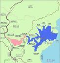
Map of Toba Port Mie. en This is map of Toba port Mie Japan Dark blue is Toba port light blue is water sea river ponds and so on pink is urban area dark green is open space schools parks factories and so on light green is land orenge is major buildings brown is Japanese national routes and yellow is Mie prefectural roads ja own


