
Related Images


Download:
| Tiny | 115x128 | View | Download |
| Small | 231x256 | View | Download |
| Medium | 463x512 | View | Download |
| Original | 657x725 | View | Download |
This image was acquired from
wikimedia. It was marked as Public Domain or CC0 and is free to use. To verify, go to the source and check the information there.
Looking for more info about this image?
Try a Google Reverse Image Search for it.
Try a Google Reverse Image Search for it.
Keywords from Image Description:
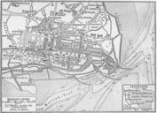
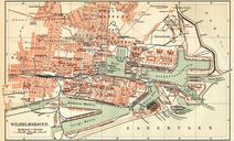
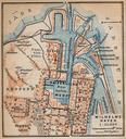
Map wilhelmshaven . Map of Wilhelmshaven Germany Source lib utexas edu Northern Germany as far as the Bavarian and Austrian Frontiers Handbook for Travellers by Karl Baedeker Fifteenth Revised Edition Leipzig Karl Baedeker New York Charles Scribner's Sons Courtesy of the University of Texas Libraries The University of Texas