
Related Images


Download:
| Tiny | 110x128 | View | Download |
| Small | 221x256 | View | Download |
| Medium | 442x512 | View | Download |
| Original | 600x694 | View | Download |
This image was acquired from
wikimedia. It was marked as Public Domain or CC0 and is free to use. To verify, go to the source and check the information there.
Looking for more info about this image?
Try a Google Reverse Image Search for it.
Try a Google Reverse Image Search for it.
Keywords from Image Description:
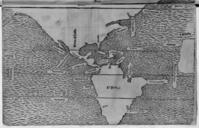
Mapa de las tierra hiperboreassigurdur stefansson. es Copia realizada por Thordur Thorlaksson de un mapa manuscrito del Atlntico Norte dibujado en por Sigurd Stfansson conservado en la Biblioteca Real de Copenague Groenlandia el promontorio de winlandia aparecen como pennsulas de un continente que se prolonga desde Escandinavia