
Related Images
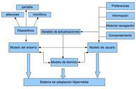


Download:
| Tiny | 91x128 | View | Download |
| Small | 182x256 | View | Download |
| Medium | 365x512 | View | Download |
| Original | 586x822 | View | Download |
This image was acquired from
wikimedia. It was marked as Public Domain or CC0 and is free to use. To verify, go to the source and check the information there.
Looking for more info about this image?
Try a Google Reverse Image Search for it.
Try a Google Reverse Image Search for it.
Keywords from Image Description:
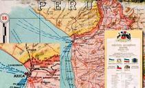
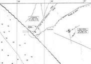
Mapa enrique brieba concordia. es Mapa del sector inicial de la frontera entre Peru Chile preparado firmado por Enrique Brieba Documento presentado por el Gobierno del Peru ante la Corte Internacional de Justicia en la Controversia Martima Per Chile rree gob pe pdf Memoria del Gobierno del Per Volumen de Marzo de Corte Internacional