
Related Images


Download:
| Tiny | 151x128 | View | Download |
| Small | 302x256 | View | Download |
| Medium | 605x512 | View | Download |
| Original svg | 650x550 | View | Download |
| Original as jpg | 650x550 | View | Download |
This image was acquired from
wikimedia. It was marked as Public Domain or CC0 and is free to use. To verify, go to the source and check the information there.
Looking for more info about this image?
Try a Google Reverse Image Search for it.
Try a Google Reverse Image Search for it.
Keywords from Image Description:
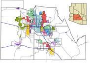
Maricopa County METRO Light Rail Map.svg Geographical map of METRO Light Rail system of Phoenix Arizona showing the starter route and future expansion corridors Also shown are city borders and highways in the vicinity of the light rail system Stops are shown as white circles and parkandride stops are shown as gray circles My own