
Related Images


Download:
| Tiny | 128x128 | View | Download |
| Small | 256x256 | View | Download |
| Medium | 512x512 | View | Download |
| Large | 1024x1024 | View | Download |
| Original png | 1688x1687 | View | Download |
| Original as jpg | 1688x1687 | View | Download |
This image was acquired from
wikimedia. It was marked as Public Domain or CC0 and is free to use. To verify, go to the source and check the information there.
Looking for more info about this image?
Try a Google Reverse Image Search for it.
Try a Google Reverse Image Search for it.
Keywords from Image Description:
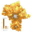
Mazowieckie density pl. gsto zaludnienia terenw wiejskich woj mazowieckiego Dane na podstawie GUS stan XII Granice gmin miast powiatw Aotearoa do wlasnoci publicznej Bogomolov PL opracowanie danych statystycznych Aotearoa grafika Maps of Masovian Voivodeship Choropleth maps