
Related Images


This image was acquired from
wikimedia. It was marked as Public Domain or CC0 and is free to use. To verify, go to the source and check the information there.
Looking for more info about this image?
Try a Google Reverse Image Search for it.
Try a Google Reverse Image Search for it.
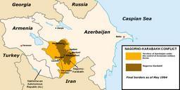
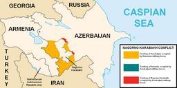
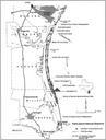
Keywords from Image Description:
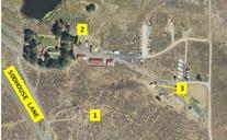
MNWR Occupation Map. Map of locations occupied by militants at Mahleur National Wildlife Refuge as per Oregon Public Broadcasting opb org Fire lookout used by militants as watch tower MNWR offices used as HQ by militants staff residential buildings used as barracks and canteen by militants nationalmap gov Geological Survey