
Related Images


Download:
| Tiny | 133x128 | View | Download |
| Small | 267x256 | View | Download |
| Medium | 535x512 | View | Download |
| Large | 1070x1024 | View | Download |
| Original | 1094x1046 | View | Download |
This image was acquired from
wikimedia. It was marked as Public Domain or CC0 and is free to use. To verify, go to the source and check the information there.
Looking for more info about this image?
Try a Google Reverse Image Search for it.
Try a Google Reverse Image Search for it.
Keywords from Image Description:
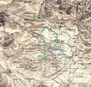
Modiins. Combination of portions of two maps produced by the Survey of Western Palestine first published in by the Committee of the Palestine Exploration Fund The editor Walter Besant died in The blue shape gives the approximate boundaries of the buildup area of Modi'in in Google Earth The green diamonds show three scientific