
Related Images


Download:
| Tiny | 145x128 | View | Download |
| Small | 290x256 | View | Download |
| Original png | 426x375 | View | Download |
| Original as jpg | 426x375 | View | Download |
This image was acquired from
wikimedia. It was marked as Public Domain or CC0 and is free to use. To verify, go to the source and check the information there.
Looking for more info about this image?
Try a Google Reverse Image Search for it.
Try a Google Reverse Image Search for it.
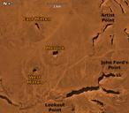
Keywords from Image Description:
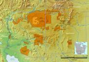
Monument valley map. en Annotated aerial image of Monument Valley main part fr Carte satellite annote de la partie principale de Monument Valley USGS The National Map via MSR Maps formerly TerraServerUSA Image from USGS Annotated by myself aspx AboutTerraServiceOverview Public domain PDUSGovUSGS Monument Valley West and East