
Related Images


Download:
| Tiny | 121x128 | View | Download |
| Small | 243x256 | View | Download |
| Medium | 486x512 | View | Download |
| Original | 595x626 | View | Download |
This image was acquired from
wikimedia. It was marked as Public Domain or CC0 and is free to use. To verify, go to the source and check the information there.
Looking for more info about this image?
Try a Google Reverse Image Search for it.
Try a Google Reverse Image Search for it.
Keywords from Image Description:
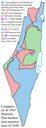
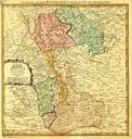
Mnster partition . en Map from showing how the territory of the PrinceBishopric of Mnster was partitioned in in the course of the German Mediatization that saw all the princebishoprics save one abolished The northern half the Niederstift was divided between the Duke of Oldenburg area in blue and the Duke of Arenberg area in pink