
Related Images


Download:
| Tiny | 158x128 | View | Download |
| Small | 317x256 | View | Download |
| Medium | 635x512 | View | Download |
| Original svg | 772x622 | View | Download |
| Original as jpg | 772x622 | View | Download |
This image was acquired from
wikimedia. It was marked as Public Domain or CC0 and is free to use. To verify, go to the source and check the information there.
Looking for more info about this image?
Try a Google Reverse Image Search for it.
Try a Google Reverse Image Search for it.
Keywords from Image Description:
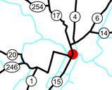
National highways in Tokyo.svg spuimap Map of the national routes running near downtown Tokyo Japan The Metropolitan Expressway is shown in light blue The red dot is the Nihonbashi Bridge where and end This is traced on Google Maps aerials routing information is from Google Maps Transport maps of Tokyo Route Japan Route