
Related Images


This image was acquired from
wikimedia. It was marked as Public Domain or CC0 and is free to use. To verify, go to the source and check the information there.
Looking for more info about this image?
Try a Google Reverse Image Search for it.
Try a Google Reverse Image Search for it.
Keywords from Image Description:
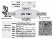
NGMDB data model application. en Figure Simplified representation of the data model and its application to typical geologic map The presence of geologic unit on the map referred to in the data model as an occurrence of that map unit is described by its bounding contacts and faults whose coordinates are stored as the unit geometry


