
Related Images


Download:
| Tiny | 94x128 | View | Download |
| Small | 189x256 | View | Download |
| Medium | 378x512 | View | Download |
| Large | 756x1024 | View | Download |
| Original gif | 1440x1950 | View | Download |
| Original as jpg | 1440x1950 | View | Download |
This image was acquired from
wikimedia. It was marked as Public Domain or CC0 and is free to use. To verify, go to the source and check the information there.
Looking for more info about this image?
Try a Google Reverse Image Search for it.
Try a Google Reverse Image Search for it.
Keywords from Image Description:
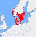
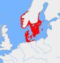
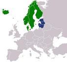
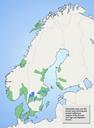
Nordic Settlements. Schematic map showing separate Nordic regions of central settlements during the Migration Period AD interpreted as at least possible petty kingdoms Based on analyses of ancient finding concentrations made by Ume University Map based on umu se html archived link archive org umu se html own Leos vn Nordic Iron