
Related Images


Download:
| Tiny | 98x128 | View | Download |
| Small | 197x256 | View | Download |
| Medium | 395x512 | View | Download |
| Large | 791x1024 | View | Download |
| Original | 850x1100 | View | Download |
This image was acquired from
wikimedia. It was marked as Public Domain or CC0 and is free to use. To verify, go to the source and check the information there.
Looking for more info about this image?
Try a Google Reverse Image Search for it.
Try a Google Reverse Image Search for it.
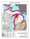
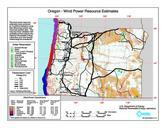
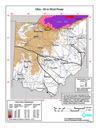
Keywords from Image Description:
Ohio wind resource map px. en Average annual wind power distribution for Ohio height above ground also showing location of existing electrical transmission lines windpoweringamerica gov United States Department of Energy National Renewable Energy Laboratory TrueWind Solutions EERE copyright policy says its works are public domain