
Related Images


Download:
| Tiny | 174x128 | View | Download |
| Small | 349x256 | View | Download |
| Medium | 698x512 | View | Download |
| Original png | 726x532 | View | Download |
| Original as jpg | 726x532 | View | Download |
This image was acquired from
wikimedia. It was marked as Public Domain or CC0 and is free to use. To verify, go to the source and check the information there.
Looking for more info about this image?
Try a Google Reverse Image Search for it.
Try a Google Reverse Image Search for it.
Keywords from Image Description:
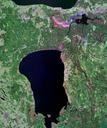
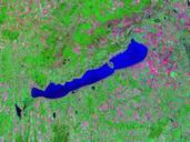
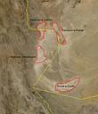
Olallie Lake Satellite Image. en Satellite Image of Olallie Lake in the Midway High Lakes Area of Washington State It lies below Mount Adams arcgis html webmap cacdeccdaecead Esri DigitalGlobe GeoEye icubed USDA USGS AEX Getmapping Aerogrid IGN IGP swisstopo and the GIS User Community PDUSGov Uploaded with ford Pinchot National