
Related Images


Download:
| Tiny | 133x128 | View | Download |
| Small | 266x256 | View | Download |
| Original png | 417x401 | View | Download |
| Original as jpg | 417x401 | View | Download |
This image was acquired from
wikimedia. It was marked as Public Domain or CC0 and is free to use. To verify, go to the source and check the information there.
Looking for more info about this image?
Try a Google Reverse Image Search for it.
Try a Google Reverse Image Search for it.
Keywords from Image Description:
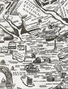
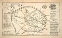
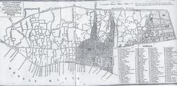
Old Ireleth map . Key Red 'Sands Road' 'Marsh Lane' now known as 'Ireleth Road' and part of the Yellow Saves Lane Purple Road heading North towards KirkbyinFurness Blue Road heading towards Marton Green Road heading over the moors to DaltoninFurness Ireleth North roughly equals up and the map shows an area of approximately The