
Related Images


Download:
| Tiny | 222x128 | View | Download |
| Small | 444x256 | View | Download |
| Medium | 889x512 | View | Download |
| Large | 1779x1024 | View | Download |
| Original | 6129x3527 | View | Download |
This image was acquired from
wikimedia. It was marked as Public Domain or CC0 and is free to use. To verify, go to the source and check the information there.
Looking for more info about this image?
Try a Google Reverse Image Search for it.
Try a Google Reverse Image Search for it.
Keywords from Image Description:
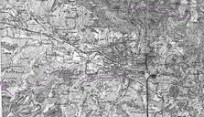
Omgeving CharlevilleMzires . en Picture taken of part of the map In particular the area around CharlevilleMzires This map shows the the main railways and the metric railways of the CFDA Chemins de fer dpartementaux des Ardennes From Mohon and Nouzon French military staf map of the area around Mzieres French military map department