
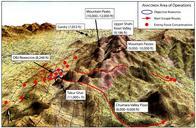
Related Images


This image was acquired from
wikimedia. It was marked as Public Domain or CC0 and is free to use. To verify, go to the source and check the information there.
Looking for more info about this image?
Try a Google Reverse Image Search for it.
Try a Google Reverse Image Search for it.
Keywords from Image Description:
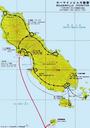
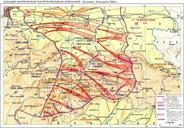
Operation Map. Approximate Route of Operation HawaiianislandchainUSGS MHmapA UTC HawaiianislandchainUSGS United States Geological Survey USGS MHmapA Hobe derivative work xx xxx xx talk Combination of two images to help illustrate Operation xx xxx xx MHmapA Category Maps of Hawaii Northwestern Hawaiian Islands Islands of