
Related Images


Download:
| Tiny | 199x128 | View | Download |
| Small | 399x256 | View | Download |
| Medium | 799x512 | View | Download |
| Large | 1599x1024 | View | Download |
| Original | 2239x1433 | View | Download |
This image was acquired from
wikimedia. It was marked as Public Domain or CC0 and is free to use. To verify, go to the source and check the information there.
Looking for more info about this image?
Try a Google Reverse Image Search for it.
Try a Google Reverse Image Search for it.
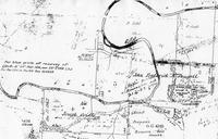
Keywords from Image Description:
Original map of St Johns Wood Ashgrove . en Section of James Warner's map showing the portion area acres purchased by John Fredrick McDougall Paten Dick Ashgrove Historical Society Ashgrove and The Gap aspects of history land access institutions and people Ashgrove Historical Society Inc ISBN page James Warner Custom marker