
Related Images


Download:
| Tiny | 205x128 | View | Download |
| Small | 411x256 | View | Download |
| Medium | 823x512 | View | Download |
| Large | 1646x1024 | View | Download |
| Original | 13211x8217 | View | Download |
This image was acquired from
wikimedia. It was marked as Public Domain or CC0 and is free to use. To verify, go to the source and check the information there.
Looking for more info about this image?
Try a Google Reverse Image Search for it.
Try a Google Reverse Image Search for it.
Keywords from Image Description:
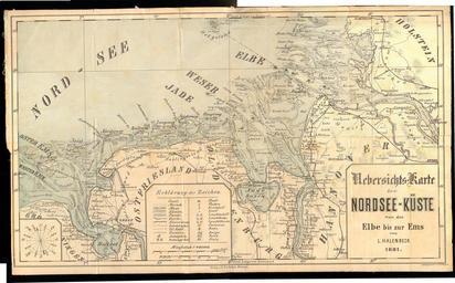
Ostfriesland. LargeImage en OverviewMap of the nortsea coast from Elbe to Ems de UebersichtsKarte der NordseeKste von der Elbe bis zur Ems published by Verlag Halem Bremen Halenbeck Authographie Dreyer User Knipptang Stitched pretty poorly I'll uplaod better version soon Maps of East Frisia Lithographs Old maps of Lower Saxony