
Related Images


Download:
| Tiny | 163x128 | View | Download |
| Small | 327x256 | View | Download |
| Medium | 654x512 | View | Download |
| Large | 1308x1024 | View | Download |
| Original png | 1464x1146 | View | Download |
| Original as jpg | 1464x1146 | View | Download |
This image was acquired from
wikimedia. It was marked as Public Domain or CC0 and is free to use. To verify, go to the source and check the information there.
Looking for more info about this image?
Try a Google Reverse Image Search for it.
Try a Google Reverse Image Search for it.
Keywords from Image Description:
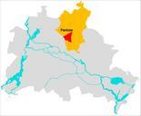
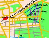
PankowSdKissingenge. de Die Lage der Straen im Bereich des heutigen Kissingenviertels in Pankow von Berlin nach der Planung wie sie sich aus dem PharusPlan von ergibt Dabei sind Grnflchen grn dargestellt und bebaute oder fr die Bebauung vorgesehene Flchen hellrot dargestellt orange ist das auf dem Stadtplan bereits dargestellte