
Related Images


Download:
| Tiny | 188x128 | View | Download |
| Small | 376x256 | View | Download |
| Medium | 752x512 | View | Download |
| Original png | 800x544 | View | Download |
| Original as jpg | 800x544 | View | Download |
This image was acquired from
wikimedia. It was marked as Public Domain or CC0 and is free to use. To verify, go to the source and check the information there.
Looking for more info about this image?
Try a Google Reverse Image Search for it.
Try a Google Reverse Image Search for it.
Keywords from Image Description:
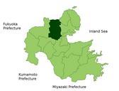
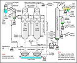
PatternRecognitionProcess. This is process flow diagram of the pattern recognition process usually used in remote sensing Following original files were used Artist representation of CERES instruments scan Earth in RAP Rotating Azimuth Plane mode Location Map of Usa in Oita Prefecture Japan Ceresrapsscan UsainOitaPrefecture UTC