
Related Images


Download:
| Tiny | 86x128 | View | Download |
| Small | 173x256 | View | Download |
| Medium | 347x512 | View | Download |
| Large | 694x1024 | View | Download |
| Original | 3532x5210 | View | Download |
This image was acquired from
wikimedia. It was marked as Public Domain or CC0 and is free to use. To verify, go to the source and check the information there.
Looking for more info about this image?
Try a Google Reverse Image Search for it.
Try a Google Reverse Image Search for it.
Keywords from Image Description:
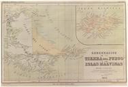
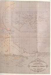
PazSoldan. Map from the Argentine Republic Geographic Atlas This geographic Atlas was made up under the direction of the geographer Mariano Felipe Paz Soldan Shown here is the plate XXVI of the Atlas headed Governship of Tierra del Fuego and the Malvinas Islands On this map the international boundary is traced along the centre