
Related Images


Download:
| Tiny | 185x128 | View | Download |
| Small | 371x256 | View | Download |
| Original png | 663x457 | View | Download |
| Original as jpg | 663x457 | View | Download |
This image was acquired from
wikimedia. It was marked as Public Domain or CC0 and is free to use. To verify, go to the source and check the information there.
Looking for more info about this image?
Try a Google Reverse Image Search for it.
Try a Google Reverse Image Search for it.
Keywords from Image Description:
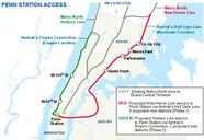
Penn Station Access Map. en Map depicting the proposed routes and new stations of MetroNorth Penn Station Access org NYCSmapR svg No machinereadable author listed on the source document other versions cczero MetroNorth construction Hudson Line New Haven Line West Side Line Northeast Corridor Maps in English