
Related Images


Download:
| Tiny | 97x128 | View | Download |
| Small | 195x256 | View | Download |
| Medium | 390x512 | View | Download |
| Large | 781x1024 | View | Download |
| Original | 4051x5309 | View | Download |
This image was acquired from
wikimedia. It was marked as Public Domain or CC0 and is free to use. To verify, go to the source and check the information there.
Looking for more info about this image?
Try a Google Reverse Image Search for it.
Try a Google Reverse Image Search for it.
Keywords from Image Description:
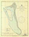
PinipelCS. en nautical chart of Pinipel Atoll Green Islands Bismarck Archipelago Papua New Guinea raremaps cfm type maps autokey Hydrographic Office Navy PDUSGovMilitaryNavy Maps of Papua New Guinea Green Islands Nautical charts