
Related Images


Download:
| Tiny | 167x128 | View | Download |
| Small | 335x256 | View | Download |
| Medium | 670x512 | View | Download |
| Original | 1061x810 | View | Download |
This image was acquired from
wikimedia. It was marked as Public Domain or CC0 and is free to use. To verify, go to the source and check the information there.
Looking for more info about this image?
Try a Google Reverse Image Search for it.
Try a Google Reverse Image Search for it.
Keywords from Image Description:
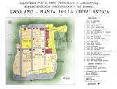
Plan Of Ancient Herculaneum. plan of the excavated area of the ancient city of Herculaneum as seen on sign at the archeological site Plan der Ausgrabungssttte der antiken Stadt Herculaneum auf einem Schild an der archeologischen Sttte own assumed AlMare Maps of Herculaneum