
Related Images


This image was acquired from
wikimedia. It was marked as Public Domain or CC0 and is free to use. To verify, go to the source and check the information there.
Looking for more info about this image?
Try a Google Reverse Image Search for it.
Try a Google Reverse Image Search for it.
Keywords from Image Description:
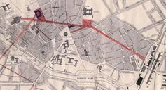
Plan original de la Perce centrale au Mans . fr La vue du plan datant de permettant de relier la gare du Mans la place des Jacobins Bibliothque Municipale du Mans Paul Chausse et Imprimerie Monnoyer Fichier dans le domaine public Archives dpartementales de la Sarthe PDold Maps of Mans