
Related Images


Download:
| Tiny | 188x128 | View | Download |
| Small | 376x256 | View | Download |
| Medium | 753x512 | View | Download |
| Large | 1507x1024 | View | Download |
| Original | 2885x1960 | View | Download |
This image was acquired from
wikimedia. It was marked as Public Domain or CC0 and is free to use. To verify, go to the source and check the information there.
Looking for more info about this image?
Try a Google Reverse Image Search for it.
Try a Google Reverse Image Search for it.
Keywords from Image Description:
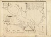
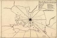
Plano de Puerto Rico situado en la parte septemtrional de la ysla de este nombre una de las de Barlovento en la lattd. de en la longd. de segn. el meridiano de Thenerife. en Shows vicinity of San Juan including fort and harbor Depths shown by soundings Prime meridian Tenerife Oriented with north to the bottom Penandink Mounted