
Related Images


Download:
| Tiny | 124x128 | View | Download |
| Small | 248x256 | View | Download |
| Medium | 497x512 | View | Download |
| Large | 994x1024 | View | Download |
| Original png | 1072x1104 | View | Download |
| Original as jpg | 1072x1104 | View | Download |
This image was acquired from
wikimedia. It was marked as Public Domain or CC0 and is free to use. To verify, go to the source and check the information there.
Looking for more info about this image?
Try a Google Reverse Image Search for it.
Try a Google Reverse Image Search for it.
Keywords from Image Description:
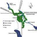
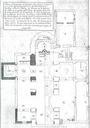
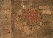
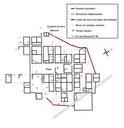
Plano Ruinas del km . map showing Ruinas del km in Chaco province Argentina These ruins correspond to Concepcin del Bermejo city which existed between and Plano de las edificaciones encontradas en las Ruinas del kilmetro departamento Maip provincia del Chaco Argentina que corresponde la extinta ciudad de Concepcin del Bermejo