
Related Images


Download:
| Tiny | 109x128 | View | Download |
| Small | 219x256 | View | Download |
| Medium | 438x512 | View | Download |
| Large | 877x1024 | View | Download |
| Original png | 2674x3122 | View | Download |
| Original as jpg | 2674x3122 | View | Download |
This image was acquired from
wikimedia. It was marked as Public Domain or CC0 and is free to use. To verify, go to the source and check the information there.
Looking for more info about this image?
Try a Google Reverse Image Search for it.
Try a Google Reverse Image Search for it.
Keywords from Image Description:
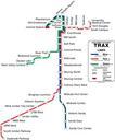
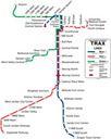
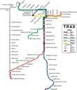
Prospective Trax map c. . en used longrange plans from the Wasatch Front Regional Council to make this map of what Salt Lake's light rail system may look like by Although lines were included in the longrange plans like the West Silver line stations were not own CL Cczero UTA TRAX maps


