Related Images


Download:
| Tiny | 170x128 | View | Download |
| Small | 341x256 | View | Download |
| Medium | 682x512 | View | Download |
| Large | 1365x1024 | View | Download |
| Original | 3264x2448 | View | Download |
This image was acquired from
wikimedia. It was marked as Public Domain or CC0 and is free to use. To verify, go to the source and check the information there.
Looking for more info about this image?
Try a Google Reverse Image Search for it.
Try a Google Reverse Image Search for it.
Keywords from Image Description:
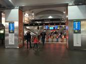
Public Transport Map At Circular Quay. en map of public transport options at Circular Quay posted alongside Sydney Trains network map and underneath Sydney Trains livery sign for Circular Quay railway station The map includes all available routes at Circular Quay by Ferry Bus and Train own Philip Terry Graham other versions heading