
Related Images


This image was acquired from
wikimedia. It was marked as Public Domain or CC0 and is free to use. To verify, go to the source and check the information there.
Looking for more info about this image?
Try a Google Reverse Image Search for it.
Try a Google Reverse Image Search for it.
Keywords from Image Description:
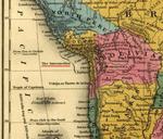
Puertos Intermedios. es Detalle del mapa de publicado por Samuel Augustus Mitchell en el que se aprecia los llamados puertos intermedios en aquel entonces dentro del Estado Sud Peruano que integraba la Confederacin PerBoliviana Mitchell's School and Family Geography Young other versions PDold History of Peru