
Related Images


Download:
| Tiny | 170x128 | View | Download |
| Small | 341x256 | View | Download |
| Medium | 682x512 | View | Download |
| Large | 1365x1024 | View | Download |
| Original | 2592x1944 | View | Download |
This image was acquired from
wikimedia. It was marked as Public Domain or CC0 and is free to use. To verify, go to the source and check the information there.
Looking for more info about this image?
Try a Google Reverse Image Search for it.
Try a Google Reverse Image Search for it.
Keywords from Image Description:
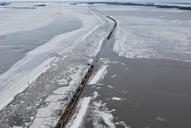
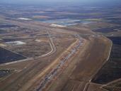
Red River Floodway from the air. Red River floodway at the southeast corner of the Winnipeg city limits near Lorette as seen from the air The Trans Canada Highway and Canadian National Railway bridges over the floodway can be seen along with the Perimeter Highway own JPark talk created this work entirely by myself June UTC JPark