
Related Images


Download:
| Tiny | 95x128 | View | Download |
| Small | 191x256 | View | Download |
| Medium | 383x512 | View | Download |
| Original | 450x601 | View | Download |
This image was acquired from
wikimedia. It was marked as Public Domain or CC0 and is free to use. To verify, go to the source and check the information there.
Looking for more info about this image?
Try a Google Reverse Image Search for it.
Try a Google Reverse Image Search for it.
Keywords from Image Description:
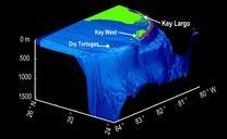
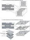
Representing threedimensional map information. en Figure Approaches for representing threedimensional map information and for managing it in the data model Vectorbased stackunit maps depict the vertical succession of geologic units to specified depth here the base of the block diagram This mapping approach characterizes the vertical