
Related Images


Download:
| Tiny | 39x128 | View | Download |
| Small | 79x256 | View | Download |
| Medium | 159x512 | View | Download |
| Large | 319x1024 | View | Download |
| Original | 727x2331 | View | Download |
This image was acquired from
wikimedia. It was marked as Public Domain or CC0 and is free to use. To verify, go to the source and check the information there.
Looking for more info about this image?
Try a Google Reverse Image Search for it.
Try a Google Reverse Image Search for it.
Keywords from Image Description:
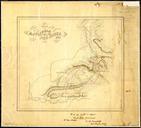
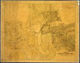
RGCWMFWBoundCommRoute. en Portion of the Map of the Oregon and Washington Territory compiled in the Bureau of Topogl Engrs chiefly for the military purposes by order of the Secretary of War Map RGCWMFW National Archives and Records Administration Cartographic and Architectural Branch Department of War other versions Washington