
Related Images


Download:
| Tiny | 111x128 | View | Download |
| Small | 223x256 | View | Download |
| Original png | 308x353 | View | Download |
| Original as jpg | 308x353 | View | Download |
This image was acquired from
wikimedia. It was marked as Public Domain or CC0 and is free to use. To verify, go to the source and check the information there.
Looking for more info about this image?
Try a Google Reverse Image Search for it.
Try a Google Reverse Image Search for it.
Keywords from Image Description:
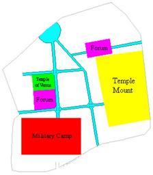
Roman Jerusalem. en Basic schematic map of Jerusalem as rebuilt by Hadrian reconstruction known as Aelia Capitolina showing the two main northsouth roads Cardo Maximus and Cardo Minimus and the two main eastwest roads Decumanus Maximus and Decumanus Minimus the northern one is in two halves It also shows other major landmarks of