
Related Images


Download:
| Tiny | 157x128 | View | Download |
| Small | 315x256 | View | Download |
| Medium | 631x512 | View | Download |
| Large | 1262x1024 | View | Download |
| Original | 4000x3244 | View | Download |
This image was acquired from
wikimedia. It was marked as Public Domain or CC0 and is free to use. To verify, go to the source and check the information there.
Looking for more info about this image?
Try a Google Reverse Image Search for it.
Try a Google Reverse Image Search for it.
Keywords from Image Description:
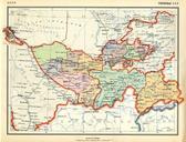
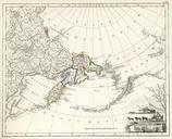
RussianEmpireMapbIrkutskayaProvinceEast. en Atlas of Russian Empire year List Eastern part of Irkutskaya Province from uyezds Chukotka land with adjacent islands and western shores of America en old map en Aleksandr Mikhaylovich Vilbrekht Author died more than years ago public domain PDold