
Related Images


Download:
| Tiny | 160x128 | View | Download |
| Small | 320x256 | View | Download |
| Medium | 641x512 | View | Download |
| Large | 1282x1024 | View | Download |
| Original | 3250x2594 | View | Download |
This image was acquired from
wikimedia. It was marked as Public Domain or CC0 and is free to use. To verify, go to the source and check the information there.
Looking for more info about this image?
Try a Google Reverse Image Search for it.
Try a Google Reverse Image Search for it.
Keywords from Image Description:
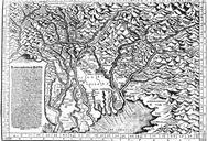
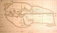
Salem Mappa . Map from showing the territory over which the Imperial Abbey of Salem exercised high jurisdiction Border stones numbered from to indicate the limits of the abbey Salem was bordered on the south by Lake Constance on the east by the PrinceBishopric of Constance on the north by the county of Heiligenberg part of the