
Related Images


Download:
| Tiny | 189x128 | View | Download |
| Small | 379x256 | View | Download |
| Medium | 758x512 | View | Download |
| Original | 776x524 | View | Download |
This image was acquired from
wikimedia. It was marked as Public Domain or CC0 and is free to use. To verify, go to the source and check the information there.
Looking for more info about this image?
Try a Google Reverse Image Search for it.
Try a Google Reverse Image Search for it.
Keywords from Image Description:
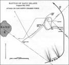
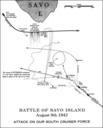
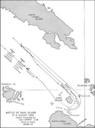
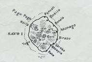
Savo Island map. en map of Savo Island of the Solomon Islands northwest of main island of Gualdalcanal Solomon Sea Pacific Ocean archaehistoria org Mapping SubSection of the st Marine Amphibious Corps that was formation of the United States Marine Corps other versions PDUSGov Maps of the Solomon Islands maps