
Related Images


Download:
| Tiny | 108x128 | View | Download |
| Small | 216x256 | View | Download |
| Medium | 433x512 | View | Download |
| Large | 866x1024 | View | Download |
| Original png | 1650x1950 | View | Download |
| Original as jpg | 1650x1950 | View | Download |
This image was acquired from
wikimedia. It was marked as Public Domain or CC0 and is free to use. To verify, go to the source and check the information there.
Looking for more info about this image?
Try a Google Reverse Image Search for it.
Try a Google Reverse Image Search for it.
Keywords from Image Description:
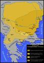
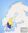
Scandinaviath century. factual accuracy map No definitions no sources The areas have been questioned and are probably accurate at most with some nonobvious definitions See org php title Faktafr Agor oldid Hurr Attvisande Ardennakarta svearochg Btar swwp Map of Scandinavia in th century showing modern borders in grey Made by Ningyou