
Related Images


Download:
| Tiny | 170x128 | View | Download |
| Small | 340x256 | View | Download |
| Medium | 680x512 | View | Download |
| Original png | 1210x910 | View | Download |
| Original as jpg | 1210x910 | View | Download |
This image was acquired from
wikimedia. It was marked as Public Domain or CC0 and is free to use. To verify, go to the source and check the information there.
Looking for more info about this image?
Try a Google Reverse Image Search for it.
Try a Google Reverse Image Search for it.
Keywords from Image Description:
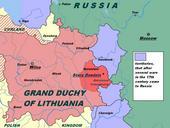
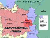
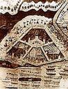
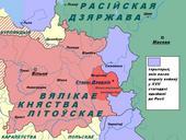
Stary Dzedzin th Century be. en This image shows the location of the village Stary Dzedzin on the political map of the th century be XVII ru XVII own Maps of Grand Duchy of Lithuania Maps in Belarusian Maps showing thcentury history