
Related Images


Download:
| Tiny | 83x128 | View | Download |
| Small | 167x256 | View | Download |
| Medium | 334x512 | View | Download |
| Original | 653x1000 | View | Download |
This image was acquired from
wikimedia. It was marked as Public Domain or CC0 and is free to use. To verify, go to the source and check the information there.
Looking for more info about this image?
Try a Google Reverse Image Search for it.
Try a Google Reverse Image Search for it.
Keywords from Image Description:
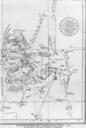
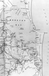
StateLibQld Map of Moreton Bay and surrounding land masses ca. . en Map of Moreton Bay and surrounding land masses ca The map shows Moreton Island Stradbroke Island before it separated into North and South Stradbroke and the mainland coastline from Deception Bay in the north to the Pimpama River in the south Bayside suburbs are