
Related Images


Download:
| Tiny | 174x128 | View | Download |
| Small | 349x256 | View | Download |
| Medium | 698x512 | View | Download |
| Original | 800x586 | View | Download |
This image was acquired from
wikimedia. It was marked as Public Domain or CC0 and is free to use. To verify, go to the source and check the information there.
Looking for more info about this image?
Try a Google Reverse Image Search for it.
Try a Google Reverse Image Search for it.
Keywords from Image Description:
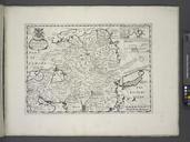
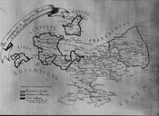
StavelotMalmdy map. en Drawing showing the late th century administrative divisions of the Principality of StavelotMalmdy From left to right the County of Logne inside heavy lines the Postellerie of Stavelot and the Postellerie of Malmdy Muse archologique de Stavelot Unknown Belgium other versions PDold Stavelot